World Maps - Professional Mapping & Cartographic Products Overview

|
MOUNTAIN HIGH MAPS® - RELIEF & VECTOR WORLD MAP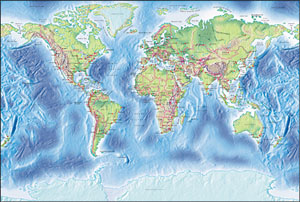
Version 4.0
unique MOUNTAIN HIGH MAPS® collection of relief maps is available for the designer who only requires a selected group of World maps for Macintosh or Windows. The map specifications are identical as for the full Mountain High Maps Edition, including both five corresponding relief JPEG Photoshop maps with a vector Illustrator EPS geopolitical map. All products include the Frontiers vector EPS material.
 MHM World Gall Relief Map #605 $19 MHM World Gall Relief Map #605 $19
MHM World Van de Grinten Relief Map #606 $19
MHM World 78 Relief Map Collection $95
Product Information |
Technical Specifications
Ocean maps |
Polar Arctic & Antarctic maps |
|
MOUNTAIN HIGH MAPS® - VECTOR WORLD MAP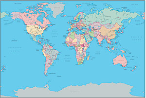
MOUNTAIN HIGH MAPS® Frontiers collection vector world wide collection of maps are available as individual downloads for Illustrator EPS Vector World maps for Macintosh or Windows. The map specifications include editable layers for all physical and political features, coastlines, borders, town locations, rivers, lake and ocean fills, scales, latitude / longitude grids, text name layers for towns, rivers, countries, and fill layers for each individual country in the world.
MHM World Gall EPS Map #605 $9
MHM World Van de Grinten EPS Map #606 $9
MHM Illustrator EPS 78 Map World Collection $29
Product and Technical Information
Ocean maps |
Arctic and Antarctic maps
|
|
WORLD RELIEF CARTOGRAPHIC STYLE 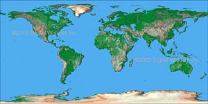
Relief texture World Map at 4 km resolution showing land relief in color variation based on elevation. The map is sized at 10,800 x 5,400 pixels, giving a printed size of 72 x 36 inches at 150 dpi, or 36 x 18 at 300 dpi. Four relief color and ocean floor texture variations of the world map are offered, each supplied with an Adobe Illustrator EPS vector map enabling a designer to build a composite world map with geo-political features -
$19.
MHM World Cartographic 4 KM Relief Map #605 $19
Product Information and Specifications
|
|
WORLD SATELLITE IMAGERY 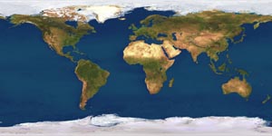
The high-resolution World coverage Satellite Imagemap, with a pixel resolution of 4 km for any location in the world, is 10,800 x 5,400 pixels in overall size - 167 megabytes of data in 24 bit RGB colour. Printed as a poster it would measure 72 x 36 inches at 150 dpi, or 36 x 18 at 300 dpi. This map can be used with the Illustrator EPS vector map to build a composite world map with geo-political features.
World 2km Satellite Map Package $29
World 4km Satellite Map Package $19
Product Information and Specifications
|
|
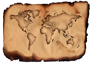 COOLMAPS® World collection of 250 bitmap JPEG and 250 EPS vector ready-to-use royalty-free World maps, each volume created specially by a team of graphic designers, featuring an imaginative array of dazzling and dramatic, artistic, thematic, textured and special effects views of the World suitable for many media publishing applications. Rights allow almost unlimited commercial use. COOLMAPS® World collection of 250 bitmap JPEG and 250 EPS vector ready-to-use royalty-free World maps, each volume created specially by a team of graphic designers, featuring an imaginative array of dazzling and dramatic, artistic, thematic, textured and special effects views of the World suitable for many media publishing applications. Rights allow almost unlimited commercial use.
Volume 1.1 World Views Vector collection styles Bulge, Curve, Flat, Globe, Perspective, Sketch, Swirl, Undulate, Vortex, Warp and Wave. Volume 1.2 World Views Bitmap collection styles: Monochrome, Blends, Flags, Outlines, Ovoids, Perspective, Stars, America, CD discs, Fabrics, Metals, Paper, Woods, Painted and Texture.
COOLMAPS World Maps Vol:1.1 - Vector EPS $19
COOLMAPS World Maps Vol:1.2 - JPEG images $19
Technical Specifications | Vol 1.1 Vector EPS Catalog | Vol 1.2 JPEG Image Catalog
|
|
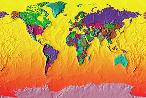 EARTHSHOTS® is a distinctive library of full color World relief maps of our planet's continents and ocean floors. 250 world view variations featuring political and topographical themes including, climate, vegetation, living standards and population. EARTHSHOTS is suitable for paper or electronic media publishing applications, print, multimedia, broadcast and DTP map graphics. EarthShots are a variation on Mountain High Maps World Gall #604.The image library is JPEG format, 14 Mb decompressed at 300 dpi.
EARTHSHOTS World Maps 250 JPEG Maps $19
Product Information | Technical Specifications | EarthShots Catalog
|
|
 GLOBESHOTS® is a distinctive collection of high quality relief globe images with enhanced 3D effect. This superb resource of 100 high resolution (300 dpi) JPEG RGB colorized globes show the world in 5 general categories and 39 specific viewpoints - equatorial, polar, strategic, oceanic and continental. The Relief Globes are presented in a range of styles and colors, with and without cloud cover, with masks and artwork to reconfigure the globes with interchangeable foregrounds and backgrounds, including blends, halo and star effects. Masks are provided to remove the globes from their background and provide shading effects. To view the complete catalog of globes and review product information and licensing details see www.globe-world.com GLOBESHOTS® is a distinctive collection of high quality relief globe images with enhanced 3D effect. This superb resource of 100 high resolution (300 dpi) JPEG RGB colorized globes show the world in 5 general categories and 39 specific viewpoints - equatorial, polar, strategic, oceanic and continental. The Relief Globes are presented in a range of styles and colors, with and without cloud cover, with masks and artwork to reconfigure the globes with interchangeable foregrounds and backgrounds, including blends, halo and star effects. Masks are provided to remove the globes from their background and provide shading effects. To view the complete catalog of globes and review product information and licensing details see www.globe-world.com
GLOBESHOTS Views from Strategic locations JPEG $19
Product Information |
Tech Specifications |
GlobeShots Catalog
|
|
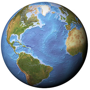 EARTH IMAGES COLLECTION is a collection of 3D globe views and maps created from Planetary Visions Satellite Imagemap, a highly realistic image of the Earth's surface derived from thousands of Earth observation satellite images. Data from 3 satellite systems were combined with digital map and terrain data to produce the natural color Satellite Imagemap. Earth-Images comprises 8 variations of Globe Views - Clouds, Clear sky, Night Sky and Ocean floor texture, all with the optional white background or black background - 1,179 total images at 5,000 meters per pixel resolution. Each image is at 22.5ş increment North or South, East and West to give complete coverage from any perspective. Also included a selection of world views focused on 3 different areas in 3 styles, and a collection of Continental Views taken from 6 locations in 3 styles each. For details see www.earth-images.com EARTH IMAGES COLLECTION is a collection of 3D globe views and maps created from Planetary Visions Satellite Imagemap, a highly realistic image of the Earth's surface derived from thousands of Earth observation satellite images. Data from 3 satellite systems were combined with digital map and terrain data to produce the natural color Satellite Imagemap. Earth-Images comprises 8 variations of Globe Views - Clouds, Clear sky, Night Sky and Ocean floor texture, all with the optional white background or black background - 1,179 total images at 5,000 meters per pixel resolution. Each image is at 22.5ş increment North or South, East and West to give complete coverage from any perspective. Also included a selection of world views focused on 3 different areas in 3 styles, and a collection of Continental Views taken from 6 locations in 3 styles each. For details see www.earth-images.com
EARTH IMAGES Satellite Views JPEG $19
Product Information |
Technical Specifications
GLOBE CATALOG:
Clear view 1 |
Clear view 2
Cloud cover 1 |
Cloud cover 2
Ocean floor 1 |
Ocean floor 2
Night lights 1 |
Night lights 2
|
CUSTOM MAPPING - Check www.custom-map.com for prompt quotes on any special map project not shown here!
Digital Wisdom Inc.
USA & Canada orders: 800-800-8560 - International orders: 804-443-9000
Digital Wisdom Inc., Box 11, Tappahannock VA 22560-0011, USA
© Digital Wisdom, Inc.
|